
9 Stunning Hikes for Fall Foliage
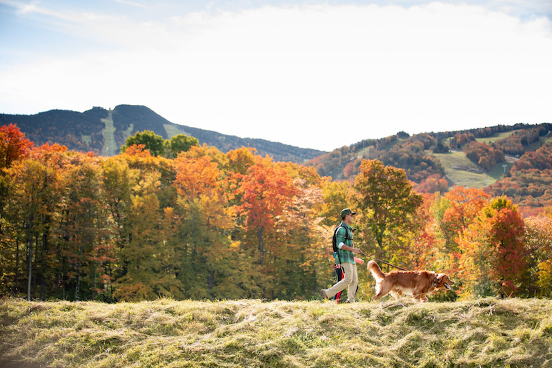
Here’s how to find the best fall foliage in ski country this season and get off the beaten path while you do it.
Autumn starts with a change in the light. Each year, it catches us by surprise, as though the earth were being catapulted into the heart of winter.
The maple trees notice it first. Bright green leaves burn to orange at the tips. The colors start to change along the ridgelines and wash down the mountainsides like wildfire, bursting with promise: snow is almost here.
By late September, you can hike up any ski trail and find spectacular views. And, generally speaking, good ski glades make for good foliage.
But if you want to find the best of Vermont’s reds and purples, look for a hike that starts low enough to take you through a hardwood forest (the more open, the more reds and oranges you’re likely to see) and ends with a vista.
Dr. Abby van den Berg, a maple researcher for the University of Vermont has spent the last 20 years studying the biochemical mechanisms by which trees such as birch, ash and maples produce fall color.
Native species such as the American beech, paper birch, gray and yellow birch produce brilliant yellow and orange leaves. Others, among them the sugar maple, also produce brilliant reds. “We still don’t fully understand why trees produce these red pigments, but we know they tend to appear in places where the leaves are directly affected by sunlight,” says van den Berg. For example, a tree standing on its own will have leaves that are red or orange toward the outer reaches of its foliage, with a swath of yellow close to the trunk.
“Often, stepping onto the trail in that northern hardwood forest, you’re in an envelope of yellow,” says van den Berg. “Even if you’re hiking through a stand of maples, you may only see red leaves at your feet. But then, you climb higher and if you look back at the ridge or hillside you just climbed, you’ll see those signature fiery reds.”
“Look for a landscape that has a lot of dark evergreens for contrast,” says van den Berg. “And don’t be afraid of a cloudy day. Sometimes low-hanging clouds bring the best light for those richer hues.”
Unlike the yellow and orange pigments, which are always present in a leaf, the reds are made new in fall, even as the leaf nears the end of its life—the last gasp of summer. “What we’re seeing are new pigments being formed in a dying organ at the time of its death,” says van den Berg.
Or, as a skier might see it, the promise of what is about to begin.
1.Mount Pisgah, Westmore
Trail: The North Trail (4.4 miles round-trip); Map: GMC Northeast Kingdom Hiking Trail Map Near: Burke Mountain Resort; Difficulty: Moderate
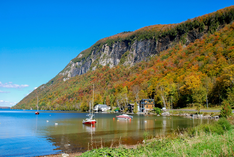
Lake Willoughby is one of Vermont’s deepest lakes. Surrounded by steep mountains, it’s often compared with a Norwegian fjord, and the slopes that surround it erupt with color come fall. This hike gives you views out across the lake’s clear, deep waters all the way to the slopes of Burke Mountain and Jay Peak. From a parking area near the southern end of Lake Willoughby on Route 5A, the trail starts on old logging roads and climbs ever upward through mixed hardwood forests to a series of footpaths that lead to two vistas; one facing north and the other facing west. Look out at the cliffs of Mt. Hor, which rises a steep 1,400 feet from the water across the lake from Pisgah (2,785 ft.) and look North for views of Lake Memphremagog, Owl’s Head and Bear Mountain.
2. Belvidere Mountain, Eden
Trail: The Long Trail (5.8 miles round-trip); Map: Green Mountain Club’s Long Trail Map; Near: Jay Peak & Smugglers’ Notch; Difficulty: Moderate
If you’re looking to beat the crowds, this is a great hike that features a fire tower as the main destination. From the parking lot on Rte. 118, head north on the Long Trail through deciduous forest, crossing Frying Pan Brook. Climb steeply through maple and beech until you reach the saddle and a 0.2-mile spur to the summit (3,340 ft.), which features stunning views to the east and a 360-degree view from the top of a 50-foot fire tower, which was restored in the 1990s. Look for views of the northern Green Mountains and New Hampshire’s Mt. Washington, as well as the nearby Cold Hollow Mountains, which are covered mostly in deciduous trees and offer great foliage. For the adventurous, try a challenging 7.9-mile loop, connecting the Frank Post Trail, the Long Trail and the Forester’s Trail. Stop for lunch at Tillotson Camp, a cozy four-sided GMC shelter with a view that overlooks a pond along the way.
3. Sterling Pond, Jeffersonville
Trail: Sterling Pond Trail (2.2 miles round-trip) or The Long Trail (6.8 miles round-trip); Near: Smugglers’ Notch Resort and Stowe Mountain Resort; Map: GMC’s Mt. Mansfield and the Worcester Range; Difficulty: Difficult
Smugglers’ Notch is a dramatic rift through the heart of some of the tallest peaks along the Green Mountain spine. Steep slopes populated by birch and maple are awash in orange and yellow at the right time of year. To get to Sterling Pond, you’ll hike up and out of the notch, climbing steeply through those glades. On the Long Trail, head up past Elephants’ Head Buttress, a 2,500-foot granite cliff that is a mecca for rock climbers across the state. Be sure to stop at the top of the cliff to take in the view, which reaches all the way down the notch to the slopes of Stowe and looks up at the Chin of Mt. Mansfield.
Once you arrive at the pond, you’ll find a shelter, the occasional loon and a 1.4-mile trail around it. If you spend the night, hike a little further to the top of Madonna Peak and take in sweeping fall foliage views from the top of Smugglers’ Notch Resort over the Lamoille Valley and north to Jay Peak, with views of the Adirondacks in the distance.
4. Hunger Mountain, Waterbury Center
Trail: The Waterbury Trail (4.2 miles round-trip); Near: Stowe Mountain Resort; Map: GMC Mt. Mansfield & The Worcester Range Hiking Trail Map Difficulty: Difficult
While everyone wants to climb Mt. Mansfield, Vermont’s highest peak, there’s an even better view from across the Stowe valley. Climbing the Worcester Range, you’ll find views of Mt. Mansfield, Camel’s Hump and, if it’s clear, all the way south to Killington. From the parking area on Sweet Farm Road, follow a blue-blazed trail that climbs through open maple and beech forests and up the western flank of Mount Hunger (3,586 ft.). Expect plenty of orange and red hues on this hike. The trail is steep and rocky, but the views from the bald summit, cleared by a long-ago forest fire, feature a 360-degree foliage extravaganza. All told, you can spot at least five ski areas from this summit, including Killington on a clear day. For added challenge and views, hike three miles north across the ridge to Hogback Mountain and descend via the Skyline Trail (1 mile), to a second vista at Stowe Pinnacle. Descend for 1.4 miles from there to the Stowe Pinnacle Trailhead, through beech and maple forest. Plan to shuttle a car.
5. Mad River Glen to Sugarbush, Waitsfield
Trails: The Long Trail (5.8 miles one-way); Map: The Green Mountain Club’s Camel’s Hump and the Monroe Skyline Map Difficulty: Moderate
The Monroe Skyline separates the Mad River Valley from the Champlain Valley and when you summit one of several peaks along the way you can see fall color all across Vermont or west to the Adirondacks and Lake Champlain. Hike from the parking area at the top of Appalachian Gap on Route 17 (adding 3.1 miles to the trip) or ride the Single Chair from the base of Mad River Glen to the Stark’s Nest warming hut. Hike the Long Trail from General Stark Mountain (3,662 ft.), past Glen Ellen Shelter, to Mt. Ellen (4,083 ft.), the top of Sugarbush North. The third highest peak in Vermont, Mt. Ellen has great views of fiery foliage on Camel’s Hump, the Worcester Range and Mt. Mansfield. After two more craggy peaks (among them Castlerock Peak, 3,812 ft.) with stunning views of the Mad River valley and Sugarbush’s famously endless yellow birch and sugar maple glades, descend to Lincoln Peak (3,975 ft.) and hike down via the Jester Trail, or download on the Super Bravo lift to Sugarbush’s Lincoln Peak courtyard.
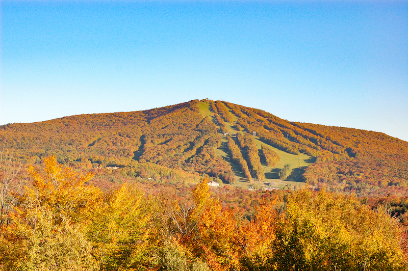
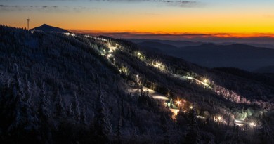
6. Killington-Pico Link, Killington
Trail: The Long Trail (5.4 miles round-trip); Map: GMC Killington Area with Ascutney and Okemo Map Difficulty: Easy
At 4,235 feet, Killington is the second tallest mountain in Vermont and features sweeping views north to Mount Mansfield and south to Ascutney, Okemo and Stratton Mountain. Start the day with an easy ride up Killington’s K1 gondola to the summit. From there, hike north on The Long Trail through boreal alpine forests, with sporadic views through the krummholz of lower foliage. After hiking over Snowden Peak (3,592 ft.) and Ram’s Head (3,600 ft.), you’ll head right at Jungle Junction, past Pico Camp to the summit of Pico Mountain (3,957 ft.) for a beautiful view. Retrace your steps to Killington and take the gondola to the main base area. While it’s a 7-mile drive from Killington to Pico, the hike is a short 2.75 miles.
7. Bromley Mountain, Winhall
Trail: The Long Trail (5.4 miles round-trip) Map: GMC Manchester Area Hiking Map with Stratton & Bromley Difficulty: Moderate
Southern Vermont’s stretch of Green Mountain National Forest has vast tracts of undeveloped land that the Long Trail traverses. Follow a white-blazed trail south from the trailhead on Rte. 11 that heads along Bromley Brook through mixed hardwood forests that should yield great yellow color with red and orange underfoot. The trail climbs steeply after 1.6 miles and at 2.3 miles, you’ll pass a spur for the Green Mountain Club’s Bromley Shelter. The trail eventually opens onto Bromley’s Run Around ski trail. Follow it to the summit for 360-degree views of the Green Mountain National Forest, with Magic Mountain to the west, Stratton Mountain to the south, Killington to the north and Mt. Equinox to the west. The Bromley Ski Patrol hut is open to hikers during the fall and summer.
8. Stratton Mountain Firetower, Stratton
Trail: Stratton Mountain Trail (7.6 miles round trip), The Wanderer Trail and Stratton Ridge Trail (5 miles round-trip); Map: Green Mountain Club Manchester Area with Stratton and Bromley Difficulty: Easy to Moderate
If you want to climb a fire tower, peer down on the largest pond along the Long Trail and get a 360-degree view of four states, take this hike up Stratton Mountain. While there are several routes that can get you there (among them, a gondola ride), all offer great foliage views. For a wilder experience on a hiking trail, opt for the longer Long Trail ascent up the mountain’s undeveloped back side. Once you reach the summit, take in the views over the ski area, then hike down approximately 50 feet on “Mike’s Way” to the old fire tower, erected by the Civilian Conservation Corps in 1934, which marks the true summit. Climb to the top of the tower for one of the best views in southern Vermont.
9. Mount Olga, Wilmington
Trail: The Mount Olga Trail (2.0 mile loop); Near: Mount Snow; Map: ; Difficulty: Easy
The summit of Mt. Olga offers some of the best views in Southern Vermont thanks to an historic fire tower at its summit that was last used as a lookout in 1974. It has a gentle grade and is a great option for families. It’s also the former home of Hogback Mountain Ski area, which operated from 1946 to 1986. The ski area land is now conserved and known as Hogback Conservation area. From the trailhead at Molly Stark State Park, the trail climbs for about a mile, first through hardwood forests and then through evergreen, where it climbs steeply to the summit. From the top of the fire tower, take in views of Western Massachusetts and Southern New Hampshire.
If a scenic ride or drive is more your speed, see “4 Must-Do Foliage Rides or Drives.”
Featured Photo Caption: At Killington, you can take in the color on a scenic gondola ride and start your hike at the summit. If you are up for an adventure, hike from there to Pico. Photo courtesy Killington Mountain Resort.
Pingback: Read the Fall Issue! – VT SKI + RIDE
Pingback: Greens to yellows to reds: Vermont foliage is in full effect – The Middlebury Campus