
Mapping the Green Mountains.. And the Moon
Two backcountry skiers took a passion for maps to a whole new level.
Matthew Parilla is a little obsessed with how you visualize data. Last spring, he started mapping Covid-19 cases across the country. “At the time, I didn’t see anyone else doing it and I needed to do it just to get my head around what was happening around my parents’ house, my sister’s house and here in Vermont.”
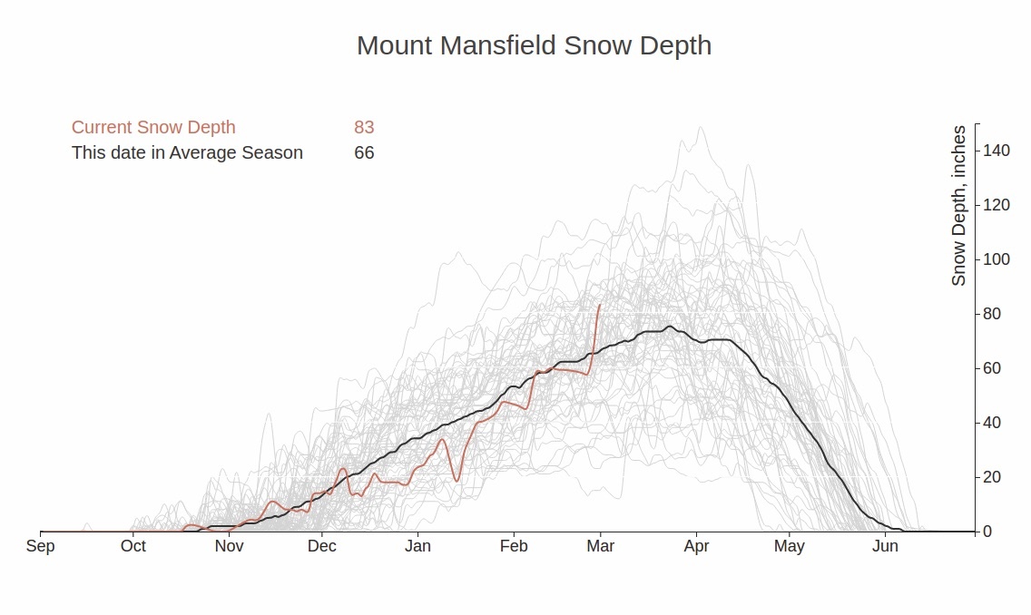
For years, Parilla, an avid backcountry skier, has also been charting the snowpack atop Mt. Mansfield. Recently, he and his business partner Brian Holdefehr started creating detailed topographic maps of the Green Mountains and elsewhere showing snowpack, forest canopies and a level of detail that no existing maps show.
While Parilla’s Ramble Maps, as he calls them, are not intended for navigational purposes, they are the types of things that skiers and riders will pore over on their walls. “For years I told my wife she couldn’t put any art on this one wall in my house because I wanted to put a map of Mt. Mansfield there.”
Now, Parilla has that map and is offering others as wall art—framed or mounted on aluminum, wood or face mounted on acrylic. Cost ranges from $79 for a loose print to $1299 for a 24 inch x 48 inch face mounted acrylic map – the kind that shows the greatest detail.
Originally from New Jersey, Parilla came to Vermont 10 years ago as a Ph.D candidate in civil/environmental engineering at the University of Vermont. He changed course though and began working as a web developer and doing data visualization for Vermont Public Radio.
“One of my first projects was to map what was going on around the state after Tropical Storm Irene.” While doing that, he learned about the Vermont Center for Geographic Information (VCGI).
“VCGI has this really high-resolution elevation data that comes from LIDAR sensors. Normally, the standard elevation you see on a contour map is 10 or 20 feet, Vermont has two-foot elevation data, so the resolution is nine times better than you see on most maps. They also take aerial imagery of the terrain at different times of the year of the tree canopy so you can actually identify what’s coniferous forest or hardwoods and visualize what it would look like in March,” he says.
Using that information and a variety of software programs, Parilla creates maps so detailed you can identify a birch tree or a pine in a beaver meadow, he says.
So far, they have made maps of 16 areas in the Green Mountains as well as mapping parts of Washington and Oregon. “I’d done some ski touring in the Northwest and found that they have really good data on the Cascades so that was the next place we mapped.”
Parilla, who lives in Richmond, is on his way to mapping all 50 states, famous peaks such as Denali, river basins such as the Colorado and making the maps in a digital format to work on cell phones. What’s next after that? “Well, I just had a guy approach me about mapping the ocean floor,” says Parilla.
The sky is the limit… or not. You can already order Ramble Maps of the moon and Mars.