
Map Maker, Map Maker Make Me A Map
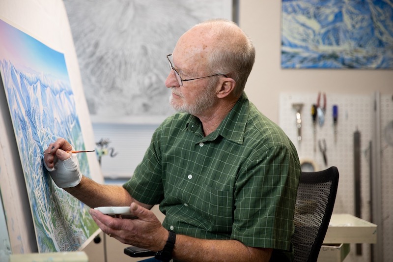
If you’ve ever pored over a trail map, marveling at the tiny trees, the shadows in the ravines and wondered how any artist could ever possibly translate what you ski on the hill into two dimensions, you probably have James Niehues to thank.
Since launching his career as a map artist, Niehues has hand-painted the trail maps for Mount Ascutney, Bromley, Haystack, Jay Peak, Killington, Pico Mount Snow, Okemo, Smugglers’ Notch, Stratton, Stowe and Sugarbush in Vermont and more than 200 ski areas, total, worldwide. In 2019, a 300-page collection of his work, James Niehues: The Man Behind the Map, was published with text by former Denver Post ski writer Jason Blevins, by Open Road Ski Company. ( $90 on jamesniehues.com.)
But one new map has been missing. So in August, 2020, when Mad River Glen realized it was seriously time for a new trail map it launched a Kickstarter campaign to have Niehues draw one. Mad River Glen was looking to raise $7,500. In less than 12 hours, they met their goal. And then some, raising over $50,000. They now have more than $80,000 from 214 backers.
“Working with Jim on this project is a dream come true for Mad River Glen,” said marketing and events director Ry Young. “A Niehues map is the map to have for any mountain, and Jim does an incredible job filling in every trail, tree and rock. Mad River Glen has plenty of those.”
The campaign will stay open through October 2 and proceeds will all go to the Stark Mountain Foundation and Mad River Glen, a skier-owned co-operative and will help print maps, add trail signage and more around the ski area.
“Mad River Glen is a unique mountain with a storied history and a deep community connection that can’t be found anywhere else,” said Niehues. “Painting the mountain’s new map, and at the same time supporting their cooperative model and the Stark Mountain Foundation is a privilege.”
Here’s our interview with James Niehaus from Fall issue, 2019, from his home in Parker, Colo.
How did the book of maps come about?
I’d been thinking about doing a book for some time and now that I’m 72, it seemed like a good time. I’d been in contact with some big publishers but one day I got a call from a fan, a skier from California named Todd Bennett, who begged me to do one. He and his business partner Ben Farrow put together everything—the printer, the writer Jason Blevins, the publicity. Then I got an offer from a big publishing company, but I decided we should stick with the folks who were skiers and passionate about it.
You launched it on Kickstarter, right?
Yes, we set a goal of raising $8,000 and we’ve raised close to $600,000. I think we set a record for illustrated books in this category on Kickstarter.
How did you start doing these maps?
I didn’t do a trail map until I was 40 years old and took on a job from another map artist, Bill Brown. I wasn’t much of a skier then, but did paint landscapes and, living in Colorado, loved the mountains.
What were the early maps you painted in Vermont?
Killington was one of the first. We’d go up in a plane, between 10 a.m. and 2 p.m., when the shadows were just right. Often, we’d fly over the summit and I’d photograph the peaks and the mountains, then drop down to mid-mountain, then down to about 500 feet above the ground. The challenge in Vermont is painting the canopy of the hardwood trees—each tree is a brushstroke. In some of the areas I’ve painted, there must be more than 500,000 trees.
Were you ever asked to make a mountain look bigger or steeper?
Oh yes—but I’m not going to say by whom. They’d say “Oh, can you just raise this a little bit?” I do distort things as sometimes you need to get everything into one view or emphasize an area that has more trails. In the end though, it all has to be relative and skiers know the difference. Making a trail map is only partly about providing directions—it’s as much about capturing a skier’s experience.
What were some of the strangest things you’ve had to draw?
I did a map of Purgatory Ski Area in Colorado once and they had this kids’ route and wanted me to put palm trees in among the other trees.
And your favorite ski area?
I loved Perisher, in Australia. Its trails fit my ability and I loved seeing parrots flying by in the trees.
Do you see computers and software taking over this role?
If you asked me that ten years ago, I probably would have said yes. But now? Not really. People ask me what software I use and I like to say ‘Gray Matter’ —meaning my brain. But a trail map is so much more than just directions. It’s a memory of the day and the experience. People love to spread trail maps out in bars at the end of the day and talk about where they skied. That’s not something you can replicate on an app or something you carry on your phone. It’s a sensation.
Featured Photo Caption: James Niehues works in his home studio in Parker, Colorado on December 17, 2018. Photo courtesy James Niehues.

Pingback: Mad River Glen, VT: Paint It If You Can? - SnowBrains
Snowbrains, you can’t just take our photos without permission. Please remove.