
La Niña, Let It Snow!
In the past few winter seasons, Ullr—god of snow—has sent Vermonters through a bit of a tail spin. In the season of 2015-16, he cursed us with the strongest El Niño on record, Last season, he graced us with storms like Winter Storm Stella, when the snow piled as high has five feet in three days.
This year, the National Oceanic and Atmospheric Administration—god of forecasting—predicts La Niña conditions. Is that good?
In a normal year, trade winds push warm surface waters in the tropical Pacific Ocean west, toward Asia, allowing deep cold water near South America to rise. During El Niño, those trade winds weaken. Warm water isn’t pushed west and cold water isn’t pushed up. In 2015, that left New England with a warm, dry winter.
La Niña is El Niño’s cousin and, in many ways, its opposite. In the year or two following El Niño, those trade winds pick back up and cold air travels up the west coast of North America.
The result? Usually, the northern U.S. becomes cold and snowy.
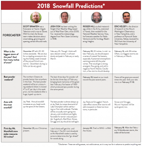
Before you break out the powder snorkels, take this warning from Eric Kelsey, director of research at the Mount Washington Observatory in Conway, N.H.: “El Niño and La Niña’s correlation with New England temperatures and precipitation is very, very loose.” On top of that, NOAA’s winter outlook for the coming winter season projects,with 40 percent certainty, that temperatures in Vermont will be warmer than average.
But according to Army-trained meteorologist Roger Hill, it’s still very possible that New England will see a snowy winter.
“Throwing my hat in there, I would say it will be a near-normal to slightly below normal-temperature winter, with probably better-than-average snowfall,” he says. “I don’t think the front side of the winter’s going to be all that impressive—skiing in the East will probably be much better in the last half of the season.”
Hill identifies three factors that will play into this season’s snowfall. The first, predictably, is La Niña—he expects it to be weak to moderate, and it’s likely to bring colder-than-average temperatures.
The second is the Arctic Oscillation, a circuit of wind that blows counterclockwise around the Arctic at about 55 degrees latitude north. It has two phases: the positive phase features a ring of strong winds that keep cold air confined within the Arctic, and in the negative phase, those winds weaken and cold air percolates south. “The AO is positive right now, so that hugs in all the cold, arctic air,” Hill says. But the Arctic Oscillation varies on a weekly basis, and if it turns negative, we will probably see snow.
Finally, wind coming from the Atlantic Ocean, where surface waters are warmer than average, will ramp up our winter snowfall events. “Storms are going to be big,” Hill says. “When they happen, they’re going to be volatile.”
And even if temperatures are above-average, as NOAA predicts, a disclaimer in their winter outlook shows that warmer temperatures don’t necessarily mean less snow. It states: “While the last two winters featured above-average temperatures over much of the nation, significant snowstorms still impacted different parts of the country.”
For now, we can cross our fingers and hope that Ullr throws us the pow.
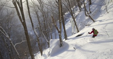
Featured photo by Brain Mohr