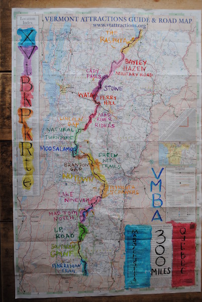
Mountain Biking Across Vermont: 301 miles in 38 hours
Stitching together our state’s best singletrack and worst trails, Calvin Decker rode the length of Vermont, 301 miles, in 38 hours.
by Calvin Decker
The alarm went off at 4:59 a.m., I got out of my sleeping bag and slipped into my bike shorts. Stars still filled the sky and excitement filled my mind. The cool morning air was thick with fog but as I drove south from my campsite Molly Stark State Park, morning’s first light crested the rolling hills. At the Massachusetts border, I went through a mental checklist: Bags in place, GPS on, SPOT beacon activated. I wanted to be rolling at 6:00. It was 5:58.
Then, “Where are my gloves? DAMMIT, WHERE ARE MY GLOVES!”Home, on my stack of clean laundry. “I hate riding without gloves!” Now barehanded, I decided to roll at 6:05.
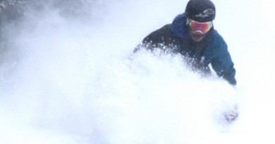
The crisp air chilled my bare hands; I was so mad at myself. “Snap out of negative thoughts. It’s a beautiful day, and you’re on your bike,” I told myself. As soon as I cleared the first mile or so of pavement, I lead myself into what would be my most enjoyable day of bikepacking in memory. Early miles ticked off quickly on winding forest service roads, often with a beautiful creek along side. A bit of grassy trail kept my feet wet, as morning dew had yet to evaporate.
Ahead were 300 more miles of dirt roads, muddy paths and singletrack and 33,000 vertical feet of climbing before I would hit my destination: Canada.
I’d been toying with the idea of riding the length of Vermont along the spine of the Green Mountains since I began bikepacking in 2013 and immediately I was hooked. At a talk on bikepacking in St. Albans, I had met Dave Tremblay, who has ridden the Tour Divide from Alberta, CA to the Mexican border, largely on trails near the Continental Divide. Tremblay and Dave Bluementhal had done extensive planning on creating a trans-Vermont route with other local riders. Working with Tom Stuessey from Vermont Mountain Biking Association, they created what is being called the Vermont Bikepacking Route (VBR), and formed the “Vermont Bikepackers” VMBA chapter
The route has seen little traffic thus far, and those who have done it have primarily ridden northbound from Massachusetts to Canada. Living in central Vermont for the last few years, I had ridden the central part of the route extensively, and expected to be on similar terrain throughout. When it came to bike choice, I went full suspension, mostly for experimentation for future plans. The initial time to beat was set earlier this summer by George Lapierre, at an impressive 54 hours, on a rigid singlespeed!
Rumors were that there was a lot of singletrack, tough double track, and rough class 4 roads. I expected my pace to be a bit slower than normal and was warned to be ready to push my bike on the hills and in the mud. Sticking to my guns, I planned to be finished within 48 hours, as I had only taken one day off of work, and wanted that day to get home and recover.
North to Moosamaloo
I had enjoyable riding along the Harriman Reservoir Trail, and onto Forest Service roads which brought me to a bit of steep pavement through the Stratton area. A road cyclist up ahead seemed to think he was god as he pedaled down the middle of the lane. As I passed, I educated him that “share the road” does not mean “own the road.” Respect gets respect. I could feel him die a little on the inside as I pedaled away on my loaded full-suspension mountain bike and his 23c tires were stuck in slow.
This paved bit lead me out to just about mile 50. After that, the route began to mature into its true character with a rough snowmobile track leading into the mountains as late morning sun began to warm the world. At mile 70, I came to a surprise supply point I missed in planning, so I grabbed a Coke and Gatorade, to surpass the boredom of water if nothing else. The trails became steeper and rougher the farther north I went.
I had yet to push my bike more than a few yards until the Plymouth area, where the trail and the stream became one of the same. I did not spend too much time distinguishing, but just pushed my bike up the shallowest part of the stream, past some folks panning for gold, until I broke out of the valley for a climb and descent into Bridgewater.
But just as I let the spokes fly, my front wheel caught a wet log in mud, and I ejected as I watched my right hand and grip disappear about 10 inches into the slop. Bare hands, slimy grips, YUCK!
I was now on my home turf. I enjoyed the familiar VASA trails between Bridgewater and Pittsfield and pedaled with a grin ear to ear. I could not maintain the 12 mph average I had been for the morning miles, but I did not expect to, and was glad to be ‘mountain’ biking!’ After a short bushwack from an abandoned class 4 into singletrack in Green Mountain Trails, the route climbs to the top of the trail system for a visit to Shrek’s Cabin. I was disappointed not to find the sign-in book, just a book of children’s poems I had already read while camping here on a previous trip. Just around 6:00 p.m., I began the fantastic descent into Pittsfield to get food for the night and next morning.
More familiar terrain lead me out of town, on a bit tougher route than I anticipated. As the sun set, I turned my lights on, more to be seen, than to see. I saw a moose cross the road a couple hundred feet ahead of me on my way up Route 73. Atop Brandon Gap, it was nearly dark, so I plugged in my headlamp, preparing for the Moosalamoo National Recreation area. The singletrack climb on Chandler Ridge was the first mental crux I had prepared for. A blast of 5-hour Energy, and I was awake, climbing, pushing a bit, but mostly riding, loving life. I still don’t know why, but there were fireworks in seemingly every direction that night, and I let my mind wander into imagining that they were celebrating my ride arriving at Silver Lake, my propsed first night camp spot.
I’m not sure if it was caffeine or excitement, but I had no desire to stop yet. Also realizing I didn’t want to attempt the entire route without sleep, I rode around the Goshen Reservoir and decided to sleep in Widow’s Clearing. The plan was to sleep about halfway up the climb, to end warm, and start with a climb in the morning to warm up.
At 11:40 p.m., I found a flat enough spot and rolled out my E-bivy and sleeping bag liner. I slipped in and forced myself to eat as much of the dry turkey sandwich as I could, but had more luck with the cookies my girlfriend Beth had made for me. I slept well, as the owls worked through the night. At 3:48 a.m., the most annoying ringtone on my phone chimed loudly in the still night. The clock was ticking, and I must ride.
I broke camp and forced in more turkey and chocolate chips. It was too early in the day to be having trouble eating real food. Wheels were rolling forward by 4:00 a.m., and I felt great.
Moosamaloo to Morrisville
The Natural Turnpike, a dirt Forest Service road between Route 125 and Lincoln Gap Road, was a perfect early morning spin, and first light greeted me as I climbed Lincoln Gap, where the sunrise was full-on through the trees as I sped down the other side. This is where the singletrack REALLY started. The Warren/ Sugarbush area lead to Waitsfield. For most of the ride through the Mad River Valley I rode technical Vermont singletrack broken up with some roads. This was fantastic. Tough, but fantastic. Many of the climbs had me either out of the saddle or out of the pedals, pushing. The descents had me whooping and loving life. THIS is what bikepacking is supposed to be!
Dave Tremblay chased me down on his motorcycle just before the Waterbury tunnel under I89 and we chatted a bit. I was starting to feel a bit tired when I hit a snag with the attendant in Little River State Park: Apparently it’s a fee area…and that slowed me down.
The singletrack from Little River up through the Stowe Mountain Bike Club trails all began to blur together as I got a chance to ride miles and miles of trail I had always wanted ride, but never had until now. I really was enjoying the ride, but I was struggling to stayed fueled, which lead to some frustration. I couldn’t stomach protein. I was living off Twizzlers, Swedish Fish, and cookies. Just before the Cady Hill tower in Morrisville, someone who had been following my SPOT beacon blip on the internet chased me down for a quick visit. It’s always rad to see people you dont know who are interested in what you’re doing. I was excited to know that this was the last of the singletrack, as I had fallen quite a bit behind my ideal pace.
A Sprint to the Border
In Morrisville, I resupplied for the last stretch. I chugged a chocolate milk while I scanned for what I could eat: Lifesaver Gummies, yup. With 50 miles and about 5,000 vertical feet left, I pedaled onto climby roads which would quickly degrade to rough and rocky paths. Not singletrack, but not much faster. Storm clouds began to build and thunder echoed through the valleys but I never got more than a sprinkle. I didn’t see anyone other than a few Jeepers buried in a mud pit deeper than their doors. They hooted and hollered as I picked my way around, never getting off the pedals.
As I cleared some of the steepest, heavily traveled, dirt road I’ve ever seen, the storms seemed to part around me. The setting sun came below the clouds, and the light shining across the valley cast amazing shadows below the dark ceiling of passing storms. My new goal: watch the sunset with Beth. The orange glow was in full effect as I sprinted into Newport for the bike path. “Calvin!” I heard a familiar voice shout. Missing the first entrance to the bike path as the GPS had me on the road, I looped around to a pedestrian bridge to say “Hi” and take a photo with the setting sun before I charged another six miles along Lake Memphremagog.
At 8:02 p.m. I arrived at the Canadian Border, finishing in 37 hours 57 minutes. I backed off the border about a mile to avoid suspicion and was nearly eaten alive by mosquitoes as I waited for my pick up.
Packing Right and Light
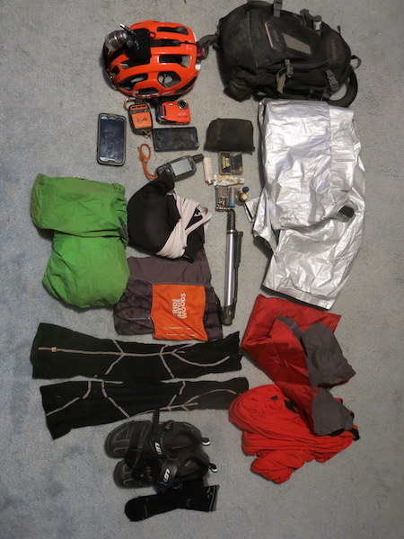
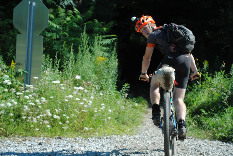
What to bring is always a toss up, depending on the course, the proposed weather, and your motive. This was my first bikepacking route with a full suspension bike. I recently purchased an Ibis Ripley that I named Ike. Without getting into mumbo jumbo tech talk, the Ripley is the most versatile bike I’ve ever ridden. Just about a week before riding the bike along the spine of the state in competitive time, I was riding lift access downhill and jump trails on the same bike!When setting up for VBR, I did not think I’d be sleeping for much more than a few hours one night. I first considered bringing just my space blanket, but I’m glad I decided to go one step heavier with the SOL E-Bivy and my usual Klymitt Pad. As far as clothing, I wore bike shorts, a jersey, and 5″ wool socks, packing a Smartwool top layer, leg warmers, and my trusty Patagonia Super Cell shell. I knew I was going to be riding through the dark, so I ran a Shutter Precision dynamo to power a USB charger and my K-Lite lighting system. I used a cheap USB headlamp, powered from rechargeable USB cache batteries, and zip-tied a blinky red light to the back of my helmet. I decided to carry a Camelbak Mule for water capacity.
Other accessories packed as listed:
-Pump
-Tube, a good one, cause tiny pumps suck
-Patch kit
-Bike tool w/ chain tool
-Spare SPD Cleat
-Chain/quick Links
-Needle
-Fiber repair spoke
-Chain lube (tiny bottle)
-Zip-ties
-Medical Tape
Also, thanks to my sponsors:
Alpine Bike Works
http://www.alpinebikeworks.com/
Nuclear Sunrise Stitchworks
http://www.nukesunrise.com/
Lonewolf Cycling
http://lonewolfcycling.com/
Surefoot USA (Insoles)
http://www.surefoot.com/